Introduction
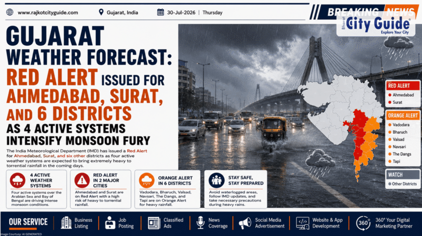
The latest updates from the official Gujarat Weather Forecast have triggered widespread concern across the state as the India Meteorological Department (IMD) escalates its weather warnings. A powerful combinations of four simultaneously active meteorological systems has formed over the region, turning this monsoon period into a critical emergency. Starting from July 30, the intensity of rain is projected to scale up drastically, culminating in a severe Red Alert on July 31 across eight major districts, including metropolitan hubs like Ahmedabad and Surat.
- Introduction
- What is a Gujarat Weather Forecast?
- Why This News is Important
- Background Information
- Key Highlights
- Detailed Explanation of the Event
- Importance of Regular Forecast Monitoring
- How It Impacts Different Sections of Society
- Industry Perspective and Expert Insights
- Challenges and Limitations
- Future Outlook
- Frequently Asked Questions (FAQs)
- Conclusion
The sheer scale of this atmospheric event is already visible on the ground. Drone footage captured across the Dholera region reveals massive flooding, with vast tracts of land completely submerged under deep sheets of water. This visual evidence highlights the immediate threat facing both urban centers and rural plains as rivers rise and drainage networks face severe capacity tests.
This tracking news is of absolute importance for every citizen, commuter, and administrative official in the state. With intense downpours capable of paralyzing transportation networks, cutting off electrical infrastructure, and disrupting daily employment, staying updated with the latest Gujarat Weather Forecast data is a matter of public safety. This comprehensive analytical report details the technical breakdown of the weather systems, localized impact maps, and the state’s expanding emergency responses.
What is a Gujarat Weather Forecast?
A Gujarat Weather Forecast is a systematic scientific assessment compiled by meteorologists to project atmospheric conditions across the state’s diverse geographic zones. Utilizing data gathered from satellite imaging, Doppler radar arrays, ocean buoys, and barometric monitoring stations, weather agencies map temperature patterns, wind trajectories, and precipitation probabilities.
For a large coastal state like Gujarat, the forecast is broken down into specific regional sub-zones:
- Saurashtra and Kutch: Generally arid or semi-arid belts that are highly prone to sudden, violent flash floods due to localized low-pressure systems over the Arabian Sea.
- South Gujarat: The state’s highest rainfall corridor, featuring heavy industrial belts like Surat and Vapi, which frequently experience prolonged monsoonal flooding.
- Central and North Gujarat: Heavily populated agricultural and urban plains, including Ahmedabad and Vadodara, where intense short-duration downpours quickly result in urban micro-flooding.
The current forecast stands out due to the integration of four active systems: a well-defined low-pressure area, a cyclonic circulation over central India, an active monsoon trough line, and an off-shore trough along the west coast. When these systems align, they act like a massive pump, pulling vast amounts of moisture from both the Arabian Sea and the Bay of Bengal directly onto land.
Why This News is Important
This specific update to the Gujarat Weather Forecast carries vital importance because it transitions the state from standard seasonal monitoring to active disaster management. A Red Alert indicates that the weather conditions pose a direct threat to life and property, demanding immediate changes to daily routines and public administrative operations.
The drone videos showing widespread flooding in Dholera serve as a strong warning. Dholera is not only a major agricultural zone but also the site of India’s flagship Smart City project (DSIR). Seeing this key economic zone surrounded by water emphasizes the real-world vulnerability of infrastructure projects to severe climate events.
Furthermore, the timing of this downpour requires close coordination from emergency services. By providing clear warnings 24 to 48 hours in advance, the forecast allows local administrators to shut down vulnerable schools, halt low-lying train operations, and position rescue teams before rising waters isolate communities.
Background Information
The 2026 monsoon season in Western India has consistently broken historical patterns, alternating between prolonged dry spells and intense, concentrated rainfall events. Climatologists point out that the state has already seen extreme, localized downpours this season, such as the sudden event that dropped 20 inches of rain on Dholka within just a few hours.
This trend fits into a broader global pattern where climate shifts alter the behavior of the South Asian Monsoon. Instead of rain spreading evenly over three months, the state now faces periods where several weeks’ worth of rain falls in a matter of days.
The convergence of four separate weather systems over a single state is an unusual event that tests municipal infrastructure. Cities like Ahmedabad and Surat, which have expanded rapidly over the years, often struggle with older drainage networks that cannot handle the immense volume of water brought by these overlapping storms.
Key Highlights
- Red Alert for July 31: A severe Red Alert is active across eight districts: Ahmedabad, Surat, Anand, Bharuch, Narmada, Vadodara, Tapi, and Dang.
- Four Systems Active: The continuous rainfall is driven by four simultaneous atmospheric systems fueling the monsoon trough.
- Dholera Flooding Captured: Drone footage confirms extensive flooding across the Dholera belt, showing water submerge fields and roads.
- Rising Rain Intensity: Current weather models show rain picking up significantly from July 30, leading into the peak danger window on July 31.
- Urban Risk Areas: Heavy urban centers face high risks of waterlogging, underpass closures, and significant traffic delays.
- Administrative Readiness: The State Emergency Operation Center (SEOC) has placed disaster response teams on high alert for immediate rescue operations.
Detailed Explanation of the Event
According to the latest technical updates from the India Meteorological Department (IMD), the atmospheric setup over Gujarat has become highly unstable. The four active systems have created a reliable path for rain clouds, continuously pushing high-altitude storm fronts across the state’s central and southern districts.
The timeline below details how the weather risks are expected to spread across different regions over the coming days:
+-------------------------------------------------------------+
|               PROJECTED REGIONAL RAIN IMPACT                |
+------------------------------+------------------------------+
| DISTRICT                     | EXPECTED IMPACT STATUS       |
+------------------------------+------------------------------+
| Ahmedabad                    | RED ALERT: Severe urban      |
|                              | waterlogging & transit halts |
+------------------------------+------------------------------+
| Surat                        | RED ALERT: High river levels |
|                              | & coastal industrial delays  |
+------------------------------+------------------------------+
| Dholera Region               | Heavy flooding; extensive    |
|                              | agricultural submergence     |
+------------------------------+------------------------------+
| Vadodara & Anand             | RED ALERT: Risk of rising    |
|                              | local river & stream levels  |
+------------------------------+------------------------------+
| North Gujarat Districts      | ORANGE ALERT: Transitioning  |
|                              | to heavy rainfall by Aug 1   |
+------------------------------+------------------------------+
As the systems intensify, the primary concern for cities like Ahmedabad and Surat is the threat of sudden, heavy downpours occurring during high-tide periods along the coast. When heavy rain aligns with a coastal high tide, urban storm drains cannot discharge water into the sea or local rivers, causing water to back up rapidly into residential streets.
In response, municipal corporations have opened round-the-clock emergency control rooms. High-capacity dewatering pumps have been deployed to low-lying areas, and local police have set up barricades near flood-prone underpasses to prevent drivers from getting stranded in deep water.
Importance of Regular Forecast Monitoring
Using the information from a regular Gujarat Weather Forecast provides distinct structural advantages for both public safety and economic stability:
- Safety for Schools: Allows local collectors to declare school holidays before students are out on flooded roads.
- Safe Travel Planning: Gives commuters the information they need to avoid flooded highways, reducing traffic jams and vehicle damage.
- Agricultural Management: Helps farmers postpone fertilizer applications or harvest mature crops early, protecting their investments from heavy rains.
- Supply Chain Continuity: Enables logistics companies to reroute trucks away from flooded parts of the national highway network.
How It Impacts Different Sections of Society
Citizens and Urban Residents
For regular city residents, the Red Alert means adjusting daily schedules and preparing for disruptions. Basement parking areas in high-rise buildings face flood risks, while ground-floor homes in low-lying sectors must take steps to protect electronics and valuables from incoming water.
Commuters and Travelers
The transportation network experiences immediate strain during these events. State transport buses frequently modify or cancel routes through heavily flooded districts, while train services face delays if water rises above the tracks. Air travel through Ahmedabad and Surat may also experience delays due to poor visibility and passing thunderstorms.
The Business and Retail Sector
Heavy, continuous rain generally leads to fewer customers in retail markets, directly reducing daily sales for small shops and street vendors. Conversely, demand typically spikes for essential goods, home delivery services, and emergency supplies like flashlights, batteries, and rain gear.
Industry Perspective and Expert Insights
Meteorologists and urban planning experts emphasize that the current situation highlights the need for dynamic, real-time weather monitoring. Weather analysts note that standard historical data is becoming less reliable for predicting modern monsoon behavior. The sudden appearance of four active systems at the same time shows how quickly localized weather patterns can escalate.
Disaster response experts also point out that while early warnings have improved, urban drainage systems remain a weak point. Civil engineers suggest that cities must look beyond simply installing more water pumps; long-term solutions require preserving natural urban wetlands and expanding green spaces to absorb heavy rainfall naturally.
Challenges and Limitations
Managing a multi-day Red Alert presents several persistent operational challenges:
- Managing Traffic in Flooded Areas: Despite clear warnings, motorists often try to drive through flooded subways, leading to stalled vehicles that block emergency rescue routes.
- Maintaining Power and Communication: Heavy downpours accompanied by strong winds can fell trees onto power lines, causing localized blackouts that disrupt internet and mobile networks.
- Protecting Temporary Shelters: Migrant workers and families living in temporary or informal housing face high risks, as their structures are often vulnerable to sustained rainfall and wind damage.
- Mitigating Drainage Blockages: Urban drainage systems are frequently slowed down by discarded plastic waste, which blocks inflow grates and causes street water to rise much faster than expected.
Future Outlook
Once the current peak period on July 31 passes, the active weather systems are expected to shift slowly toward North Gujarat and parts of neighboring Rajasthan. While this movement will ease the immediate pressure on South and Central districts, North Gujarat will need to prepare for its own round of heavy rainfall.
Over the coming years, the increasing frequency of these multi-system storms will likely drive changes in how the state builds its infrastructure. We can expect to see more investment in real-time flood monitoring sensors, upgraded drainage systems for major industrial areas like Dholera, and stricter enforcement of flood-zone regulations to protect growing cities.
Frequently Asked Questions (FAQs)
1. What does the latest Gujarat Weather Forecast predict for July 31?
The forecast has issued a severe Red Alert for July 31, warning of heavy to extremely heavy rainfall across eight major districts, including Ahmedabad and Surat.
2. How many weather systems are currently active over the state?
There are four distinct atmospheric systems working together to draw large volumes of moisture over Gujarat, driving this period of heavy rainfall.
3. Which specific districts are under the Red Alert?
The eight districts under a Red Alert are Ahmedabad, Surat, Anand, Bharuch, Narmada, Vadodara, Tapi, and Dang.
4. What is the current situation in the Dholera region?
Recent drone footage shows extensive flooding across Dholera, with floodwaters covering large agricultural fields and local roads.
5. How does an IMD Red Alert differ from an Orange Alert?
An Orange Alert advises residents to prepare for severe disruptions, while a Red Alert signifies extremely dangerous weather and calls for immediate action to protect lives and property.
6. Will public transportation be affected by the heavy rains?
Yes, heavy waterlogging often leads to closures of low-lying underpasses, delays or route changes for state buses, and potential service interruptions for local trains.
7. Where can I find reliable, real-time weather updates for my area?
Residents should follow updates from the official India Meteorological Department (IMD) website, verified state disaster management portals, and local municipal corporation alerts.
Conclusion
The latest updates from the Gujarat Weather Forecast emphasize the need for high alertness and careful preparation across the state. With four active atmospheric systems bringing heavy rain and a strict Red Alert issued for major hubs like Ahmedabad and Surat, public safety depends on proactive planning. The drone footage from Dholera shows how quickly heavy rainfall can affect regional infrastructure, reminding everyone of the power of the monsoon.
During this period of severe weather, citizens should prioritize safety by staying indoors when possible, avoiding flooded roads, and following directives from local authorities. By staying informed through reliable forecast updates and taking sensible precautions, communities can stay safe and resilient through this intense phase of the monsoon season.