Introduction
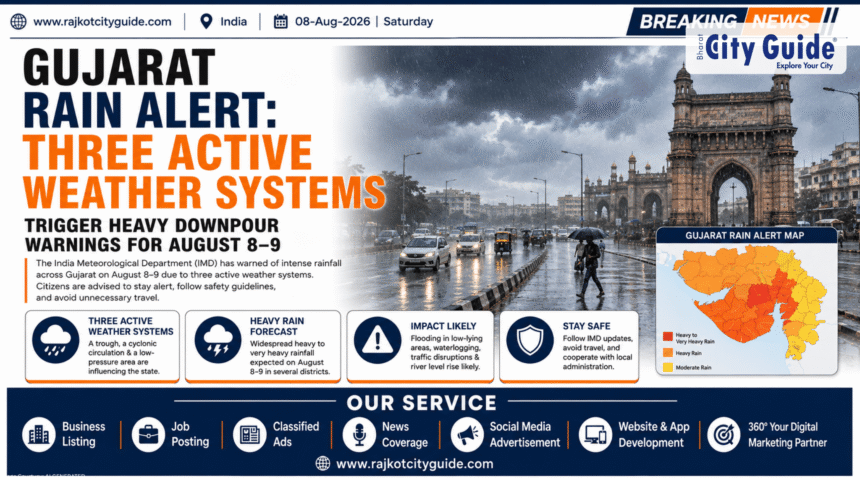
Monsoon activity across Western India has taken a dramatic turn as the India Meteorological Department (IMD) issued a critical Gujarat Rain Alert for the second week of August. Meteorological authorities have confirmed that three distinct atmospheric weather systems have activated simultaneously over the state and adjoining regions. This unique convergence is set to reignite intense monsoon showers, with heavy to very heavy precipitation projected particularly across South, Central, and North Gujarat regions on August 8 and 9.
- Introduction
- What is Gujarat Rain Alert?
- Why This News is Important
- Background Information
- Key Highlights
- Detailed Explanation of the Event
- Regional Breakdown & District Impact
- Importance and Benefits of the Forecasted Rain
- How It Impacts People
- Safety Guidelines for Citizens
- Expert Insights & Meteorological Perspective
- Challenges and Limitations
- Future Outlook
- Frequently Asked Questions (FAQs)
- Conclusion
The immediate impact of these active atmospheric systems includes widespread rainfall accompanied by lightning, localized thunderstorms, and strong surface winds reaching speeds of 30 to 50 kilometers per hour. A official yellow alert has already been declared across key northern districts, including Sabarkantha, Aravalli, Banaskantha, and the border belts of Vav and Tharad. Simultaneously, coastal maritime operations have been put on high alert, with strict advisories issued to local fishermen urging them to avoid venturing into the Arabian Sea due to turbulent sea conditions and high water swells.
Understanding the magnitude and trajectory of this meteorological development is paramount for residents, agricultural communities, urban planners, and district administrations alike. After a brief lull in rainfall that caused sultry weather and high humidity across major urban hubs like Ahmedabad and Vadodara, this active monsoon spell promises crucial water replenishment for reservoirs while simultaneously bringing acute operational challenges like urban flooding, waterlogging, and travel disruptions.
What is Gujarat Rain Alert?
A Gujarat Rain Alert represents an official meteorological advisory issued by the India Meteorological Department (IMD) via its regional center in Ahmedabad. These alerts serve as standardized public warning mechanisms designed to inform emergency responders, local governance bodies, agricultural stakeholders, and the general public about impending severe weather events.
When atmospheric parameters indicate heavy rainfall, severe thunderstorms, atmospheric depressions, or tropical cyclonic activity, the IMD categorizes warnings using a globally recognized color-coded system:
- Green Alert (No Action Needed): Represents normal atmospheric conditions with light or routine seasonal showers.
- Yellow Alert (Be Aware): Advises residents and local authorities to monitor weather forecasts closely, as hazardous weather conditions like heavy isolated rain or strong gusty winds are expected.
- Orange Alert (Be Prepared): Indicates a high probability of severe weather capable of causing disruption to transport, power supply, and localized inundation.
- Red Alert (Take Action): Denotes extreme weather events requiring immediate disaster management protocols, evacuation of vulnerable low-lying areas, and emergency relief mobilization.
The recent alert issued for August 8 and 9 falls primarily under the Yellow Alert category, signifying that while disaster scenarios are not guaranteed statewide, specific pockets in North and South Gujarat face elevated risks of heavy downpours, localized flash flooding, and lightning strikes.
Why This News is Important
The latest Gujarat Rain Alert is of major importance due to its timing, geographical spread, and structural meteorology. August is traditionally a crucial month for the Indian summer monsoon, dictating both crop survival and reservoir storage levels required to sustain cities and agriculture through the upcoming winter and summer months.
First, the simultaneous activation of three distinct weather systems—specifically a well-positioned monsoon trough, an active western disturbance, and a cyclonic circulation—is an atmospheric configuration that concentrates dense moisture over Gujarat. This combination significantly increases the probability of short-duration, high-intensity rainfall events, commonly known as cloudburst-like spells, which can overwhelm municipal drainage networks in hours.
Second, the economic stakes are exceptionally high. Agriculture forms the backbone of Gujarat’s rural economy. Crops like cotton, groundnut, castor, and sesame currently stand at critical vegetative growth stages. While rainfall is essential, excessive waterlogging without adequate drainage can destroy standing crops, lead to root rot, and trigger severe economic losses for farmers.
Finally, urban infrastructure in major metropolitan regions like Ahmedabad, Surat, Vadodara, and Rajkot remains highly sensitive to monsoon spikes. Inundated underpasses, disrupted road transport, power outages, and potential dam water releases necessitate proactive administrative prep work and public awareness.
Background Information
To fully comprehend the current weather forecast, one must examine the monsoon trajectory of Gujarat throughout the current season. Gujarat’s geographical position—bordered by the Arabian Sea to the west and south, and arid landmasses to the north and east—makes its weather dynamics uniquely vulnerable to shifting maritime air masses.
During the initial weeks of the monsoon season, Gujarat experienced erratic rainfall distribution. While coastal belts in South Gujarat received heavy precipitation early on, regions across Saurashtra, Kutch, and North Gujarat faced sporadic dry spells accompanied by high heat and humidity levels.
By mid-season, major hydrological lifelines, including the Sardar Sovar Dam on the Narmada River, recorded healthy water storage levels (surpassing 79% capacity). However, several medium and small reservoirs in North Gujarat remained below optimal levels, creating a water deficit for local irrigation networks.
The current meteorological setup developed as a low-pressure anomaly interacted with the seasonal monsoon trough stretching across northern-central India. As a western disturbance drifted across northern latitudes, it drew an immense volume of Arabian Sea moisture directly over the Gujarat landmass, triggering the multi-system event observed today.
Key Highlights
- Three Active Weather Systems: A monsoon trough, an active western disturbance, and upper-air cyclonic circulations are driving intense moisture inflow across Gujarat.
- Peak Alert Dates: August 8 and 9 are identified as the primary days for heavy rainfall activity.
- Yellow Alert Districts: Sabarkantha, Aravalli, Banaskantha, Vav, Tharad, Patan, and Mehsana face high-intensity rain warnings.
- Wind Warnings: Surface winds are projected to reach speeds between 30 and 50 km/h, accompanied by severe lightning activity.
- Maritime Safety Advisories: Fishermen have been strictly advised to abstain from navigating the Arabian Sea off the Gujarat coast due to rough sea currents.
- South and Central Gujarat Conditions: Light to moderate rain with heavy isolated spells predicted across Surat, Navsari, Valsad, Dang, Vadodara, Bharuch, and Chhota Udepur.
- Urban Center Impact: Ahmedabad and Gandhinagar are expected to experience generally cloudy skies, intermittent spells of thundershowers, and temporary heat relief.
Detailed Explanation of the Event
The Atmospheric Mechanics Behind the Rain
The current surge in rainfall is not an isolated local event but the direct outcome of a complex synoptic meteorological phenomenon. Three key systems are interacting over the region:
- The Monsoon Trough: The seasonal low-pressure line stretching across the Indian subcontinent has shifted south of its normal position, pulling moisture directly into Western India.
- Western Disturbance: An extratropical storm originating over the Mediterranean region has moved eastwards, interacting with tropical monsoonal moisture. This interaction amplifies cloud vertical development, leading to sudden, intense thunderous downpours.
- Cyclonic Circulation: A localized mid-tropospheric cyclonic movement over Gujarat and adjoining Rajasthan acts as a suction pump, drawing dense rain clouds from the Arabian Sea directly over the state.
Monsoon Trough (Southward Shift)
        +
Western Disturbance (Extratropical Moisture)
        +
Cyclonic Circulation (Arabian Sea Draw)
        =
INTENSIFIED GUJARAT RAIN ALERT (AUG 8-9)
Regional Rainfall Progression (August 6 to August 9)
The distribution of rain follows a clear geographical progression moving from South-Central areas to Northern districts:
August 6–7: Initial Phase
During the initial phase, rainfall focused heavily on South Gujarat and eastern tribal belts. Districts such as Vadodara, Chhota Udepur, Narmada, Bharuch, Surat, Tapi, Navsari, Valsad, and Dang witnessed light to moderate showers. Intermittent rain was also recorded in Dahod, Mahisagar, and parts of Aravalli, alongside the Union Territories of Daman and Dadra & Nagar Haveli.
August 8: Escalation Phase
Rainfall intensity escalates dramatically on August 8. The primary focus shifts towards North Gujarat and the northeast borders. IMD issued a Yellow Alert specifically targeting Sabarkantha and Aravalli districts, warning of isolated heavy downpours accompanied by squally winds clocking 40–50 km/h.
August 9: Peak Intensity Phase
The weather system consolidates over the northern and north-western regions. The Yellow Alert expands to cover Banaskantha, Vav, Tharad, Sabarkantha, and Aravalli. Heavy to very heavy localized rainfall is anticipated in these agricultural heartlands.
Regional Breakdown & District Impact
| Region | Districts Affected | Forecast Severity | Key Risk Factors |
| North Gujarat | Banaskantha, Sabarkantha, Aravalli, Patan, Mehsana, Vav-Tharad | High (Yellow Alert) | Localized flash floods, field inundation, lightning |
| South Gujarat | Surat, Navsari, Valsad, Dang, Tapi, Bharuch, Narmada | Moderate to High | Coastal swells, high soil saturation, river level rise |
| Central Gujarat | Vadodara, Ahmedabad, Gandhinagar, Dahod, Mahisagar, Anand | Moderate | Urban waterlogging, commuter delays, traffic gridlock |
| Saurashtra & Kutch | Rajkot, Jamnagar, Bhavnagar, Junagadh, Kutch, Amreli | Light to Moderate | Scattered thundershowers, squally coastal winds |
Importance and Benefits of the Forecasted Rain
While heavy weather alerts raise valid safety concerns, this active rain spell brings critical long-term advantages for Gujarat’s ecology, agriculture, and water management infrastructure.
Hydrological Replenishment
Gujarat relies heavily on its network of dams and reservoirs for drinking water, industrial supply, and year-round irrigation. Major structures like the Sardar Sarovar Dam benefit significantly from catchment area inflows triggered by multi-system weather events. Smaller regional reservoirs in North Gujarat, which were hovering at lower capacities, are set to receive essential fresh water inflows.
Ground-Water Recharge
Intense monsoon spells aid substantially in replenishing deep groundwater tables across arid and semi-arid districts like Banaskantha and Patan, reducing the reliance on borewells during non-monsoon months.
Thermal Relief for Urban Areas
In the days leading up to the forecast, cities such as Ahmedabad, Gandhinagar, and Vadodara experienced elevated humidity and high heat indexes. The influx of rain-bearing clouds lowers ambient temperatures significantly, providing much-needed comfort to residents.
How It Impacts People
An active weather alert of this scale influences various segments of society in distinct ways:
1. Farmers and Agricultural Producers
- Positive Impact: Rain fills farm ponds, rejuvenates soil moisture, and satisfies water requirements for cash crops during their vegetative development.
- Adverse Impact: Excessive waterlogging without proper outflow can cause seed damage, soil erosion, and fungal infestations in standing crops.
2. Urban Residents and Daily Commuters
- Road commuters face delayed transit times due to waterlogged roads, low visibility, and frequent traffic slow-downs.
- Residents living in low-lying urban sectors or near storm-water drains face potential water ingress into homes if municipal drainage capacity is exceeded.
3. Coastal Communities and Fishermen
- Fishermen face total suspension of fishing operations due to rough sea conditions and high-velocity winds.
- Coastal villages must remain vigilant against wave action and sudden storm surges during peak high tides.
4. Travelers and Tourists
- Road travel across state highways in North Gujarat (especially routes leading towards Rajasthan) requires extreme caution due to reduced visibility and slippery conditions.
- Eco-tourism in hill stations like Saputara (Dang) and forest areas in Sabarkantha will see increased scenic beauty but elevated risks of minor landslides or fallen trees.
Safety Guidelines for Citizens
To minimize risk during the active Gujarat Rain Alert period, emergency response agencies recommend adhering to fundamental safety protocols:
Before Heavy Rainfall
- Inspect private drainage systems and remove debris blocking gutters.
- Secure outdoor items, hoardings, and temporary structures that could be dislodged by 50 km/h wind gusts.
- Charge essential electronics, power banks, and flashlights in case of localized grid outages.
During Severe Rain and Thunderstorms
- Avoid standing under tall trees, metal poles, or isolated power transformers during lightning strikes.
- Do not attempt to drive or walk through flooded underpasses or fast-moving water streams—6 inches of moving water can knock down an adult, and 12 inches can sweep away a light vehicle.
- Keep emergency contact numbers (such as local disaster management cells and state helpline 1077) accessible.
Expert Insights & Meteorological Perspective
Meteorological experts and climate analysts emphasize that monsoon patterns over Western India are showing an increased frequency of compressed, high-intensity rain events. Rather than receiving steady, light precipitation over several weeks, regions are increasingly observing rapid moisture convergence events driven by interacting weather systems.
According to atmospheric scientists, the convergence of a western disturbance with a tropical monsoon trough creates deep convective clouds capable of delivering 50–100 mm of rain within span of a few hours. Experts note that while weather forecasting models have become remarkably accurate at predicting synoptic-scale patterns, local urban authorities must matching these forecasts with rapid-response drainage management to avoid urban flash floods.
Challenges and Limitations
Managing a multi-district heavy rainfall alert presents several systemic challenges:
- Urban Drainage Bottlenecks: Older storm-water infrastructure in rapidly expanding urban centers often struggles to clear rainfall exceeding 25–30 mm per hour.
- Agricultural Water Retention: Soil type variations across Gujarat mean that while sandy soils in North Gujarat absorb water relatively quickly, heavy clay soils in Central and South Gujarat hold standing water for longer periods, increasing crop vulnerability.
- Power and Connectivity Outages: Gusty winds reaching 50 km/h frequently cause tree branches to snap onto overhead power lines, causing localized blackouts and telecom disruptions.
Future Outlook
Looking past the immediate window of August 8 and 9, meteorological models indicate that atmospheric pressure over Gujarat will gradually stabilize by early next week. While localized scattered rain will continue across South Gujarat and the coastal Saurashtra belt, the intensity of severe thunderstorms in North Gujarat is expected to subside post-August 10.
However, as the mid-monsoon season continues, atmospheric conditions over the Bay of Bengal and Arabian Sea remain dynamic. District administrations are maintaining emergency control rooms in active readiness through the rest of the month to handle potential subsequent monsoon pulses.
Frequently Asked Questions (FAQs)
What is the latest Gujarat Rain Alert forecast for August 8 and 9?
The IMD has issued a Yellow Alert forecasting heavy rainfall, strong gusty winds (30–50 km/h), and lightning for several districts in Gujarat, particularly Sabarkantha, Aravalli, Banaskantha, Vav, and Tharad on August 8 and 9.
Which weather systems are responsible for this heavy rain forecast?
Three weather systems are active simultaneously: a southward-shifted monsoon trough, an active western disturbance, and a mid-tropospheric cyclonic circulation drawing moisture from the Arabian Sea.
Which districts are under a Yellow Alert in Gujarat?
A Yellow Alert has been placed on Sabarkantha and Aravalli for August 8, expanding to include Banaskantha, Vav, Tharad, Sabarkantha, and Aravalli on August 9. Neighboring districts in North and Central Gujarat also face heavy isolated spells.
Is it safe for fishermen to venture into the sea during this period?
No. The IMD has issued a strict advisory instructing fishermen not to venture into the Arabian Sea along and off the Gujarat coast due to high wind speeds and turbulent sea conditions.
How will this rain impact major cities like Ahmedabad and Surat?
Ahmedabad, Gandhinagar, Vadodara, and Surat are expected to experience generally cloudy skies with light to moderate thundershowers. While these showers offer relief from heat, temporary urban waterlogging in low-lying areas remains possible.
How does this rainfall spell affect local agriculture?
The rain provides vital moisture for standing crops like cotton, groundnut, and castor. However, farmers in yellow alert zones must ensure adequate drainage in their fields to prevent long-term waterlogging and crop damage.
What should citizens do during a lightning thunderstorm warning?
Stay indoors, avoid using corded electrical appliances, stay away from metal structures and tall isolated trees, and refrain from wading through flooded roadways or open drains.
Conclusion
The active Gujarat Rain Alert for August 8 and 9 highlights the atmospheric intensity of the ongoing monsoon season. Powered by three converging weather systems, the impending heavy downpours promise significant hydrological benefits for the state’s dams, reservoirs, and groundwater tables. At the same time, the presence of strong wind gusts, lightning, and heavy isolated showers necessitates caution among citizens, farmers, commuters, and maritime workers. By following IMD advisories, staying updated via official local weather reports, and adopting basic precautionary measures, residents across Gujarat can stay safe while making the most of this vital monsoon season.