Introduction
Monsoon fury has returned to Western India with devastating force, triggering a high-priority Gujarat Heavy Rain Alert across the state. A powerful, slow-moving atmospheric vortex hovering directly over the region has brought relentless downpours. This meteorological phenomenon has transformed seasonal showers into a full-scale flood emergency within less than 48 hours. From urban tech corridors to rural farming belts, normal life has ground to a complete standstill. Rivers are breaching danger marks, city streets have turned into roaring channels of water, and critical transport routes are heavily compromised.
- Introduction
- What is the Gujarat Heavy Rain Alert? Gujarat Samachar
- Why This News Matters
- Background Information
- Key Highlights
- Detailed Explanation of the Event
- Importance of Early Warning Systems
- How It Impacts Different Segments of People
- Industry and Expert Insights
- Challenges and Roadblocks in Rescue Operations
- Future Outlook
- Frequently Asked Questions (FAQs)
- Conclusion
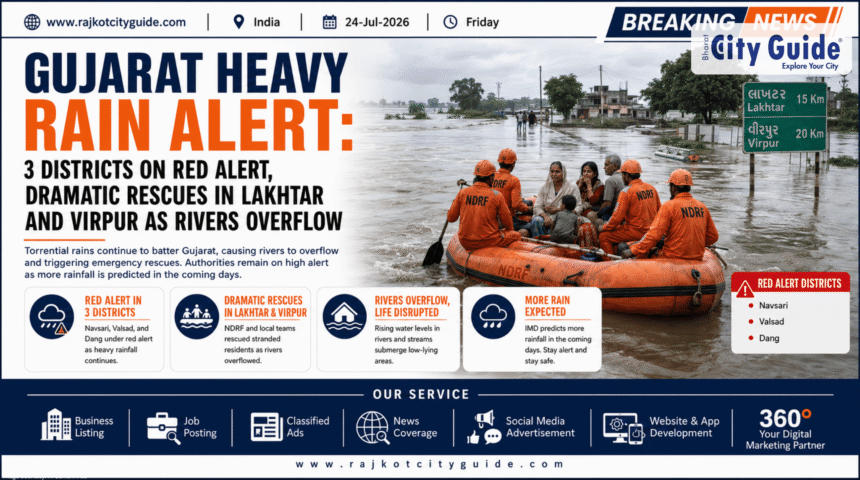
The latest field reports paint a harrowing picture of nature’s unpredictable power. In Virpur, a private car carrying two passengers was swept away by a sudden surge while trying to cross an overflowing causeway. Meanwhile, in Lakhtar, a massive coordinated operation led by rescue agencies successfully evacuated 27 stranded citizens via specialized rescue boats. In the industrial hub of Surat, local “khadis” (tidal creeks) have risen to critical, dangerous thresholds, threatening adjacent residential colonies and manufacturing zones.
With the India Meteorological Department (IMD) issuing immediate Red Alerts for three vulnerable districts and Orange Alerts for thirteen others, the situation remains highly volatile. Understanding the sheer scale of this weather event is critical for residents, travelers, and businesses operating across the state. This comprehensive report covers the ground realities of the current flood emergency, the ongoing rescue actions, and crucial safety directives.
What is the Gujarat Heavy Rain Alert? Gujarat Samachar
The Gujarat Heavy Rain Alert is a comprehensive, multi-tiered weather warning protocol activated by the India Meteorological Department (IMD) in coordination with the Gujarat State Disaster Management Authority (GSDMA). It is designed to signal extreme precipitation events that pose an immediate risk to human life, livestock, infrastructure, and public health.
Under this framework, warnings are categorized into color-coded tiers based on severity:
- Red Alert: Warns of isolated exceptionally heavy rainfall exceeding 204.4 mm in a single 24-hour window. It demands immediate, proactive institutional intervention to prevent loss of life.
- Orange Alert: Signals very heavy rain conditions (ranging between 115.6 mm and 204.4 mm). This requires administrative readiness, localized evacuations, and public vigilance.
- Yellow Alert: Indicates watchfulness for moderate to heavy showers that could cause minor localized disruptions.
The current alert stands out due to the presence of a “stationary atmospheric vortex”. Unlike standard monsoon systems that sweep across the subcontinent quickly, this cyclonic vortex has remained static over the Gujarat landmass. This traps moisture-laden winds from the Arabian Sea and dumps extreme amounts of water over concentrated zones over consecutive days.
Why This News Matters
This developing situation demands national attention due to its widespread humanitarian, logistical, and economic consequences. The safety of thousands of citizens in low-lying pockets hangs in the balance, requiring rapid response from the National Disaster Response Force (NDRF) and State Disaster Response Force (SDRF).
Furthermore, Gujarat serves as a critical economic engine for India. It houses major manufacturing hubs, chemical refineries, textile industries, and vital maritime ports. Prolonged waterlogging in economic epicenters like Surat, Vapi, and Ahmedabad disrupts national supply chains, halts factory production, and inflicts major financial losses. Additionally, structural failures—such as washed-away bridge diversions, cracked highways, and compromised power grids—cost the public exchequer heavily and hamper long-term regional development.
Background Information
The monsoon season of 2026 has brought unusual precipitation patterns across Western India. By mid-July, Gujarat had already recorded nearly 29% of its cumulative seasonal average rainfall, totaling 261.59 mm. The southern territories, particularly Valsad, Navsari, and the Dang district, bore the brunt of these early deluges, forcing over 8,300 residents out of vulnerable zones.
| Region/Taluka | Recorded Rain Accumulation | Key Operational Impact |
|---|---|---|
| Pardi (Valsad) | 208 mm (8.19 inches) | Severe urban inundation |
| Khergam (Navsari) | 202 mm (7.95 inches) | Rural flash flooding |
| Vapi Industrial Zone | 182 mm (7.17 inches) | Submerged arterial pathways |
| Umarpada (Surat) | Exceeded 150 mm | Extreme rise in local creeks |
As these initial downpours saturated the topsoil, the state’s reservoir systems quickly filled up. The massive Sardar Sarovar Narmada Dam climbed to over 67% of its total capacity, prompting engineers to monitor intake levels closely. When the atmospheric vortex stalled over the region on July 23–24, the saturated ground could no longer absorb the moisture, resulting in instant surface runoff and flash floods.
Key Highlights
- Red Alert Activation: The IMD placed 3 core districts under a strict Red Alert for extreme downpours, while 13 districts operate under an Orange Alert.
- Virpur Flash Flood Incident: A private vehicle carrying two occupants was swept into a raging river current; emergency search operations are active.
- Lakhtar Boat Rescue: Disaster management teams deployed inflatable motorboats in Lakhtar to rescue 27 people trapped by rising floodwaters.
- Surat Khadi Overflows: Tidal creeks in Surat have reached hazardous levels, putting surrounding urban slums and industrial sectors on high alert.
- Widespread Road Closures: Over 220 state highways, rural links, and key bridge diversions have been closed to vehicular traffic due to safety risks.
- Military Readiness: The Indian Air Force (IAF) and the Indian Coast Guard have placed helicopter crews on standby for potential air-rescue operations once weather conditions allow.
Detailed Explanation of the Event
The Shocking Incident in Virpur
In Virpur, a dangerous rescue scenario unfolded when a driver attempted to cross a low-lying bridge structure during active flooding. The river’s current quickly overwhelmed the car’s weight, lifting the vehicle and dragging it downstream with two individuals trapped inside. Emergency teams were dispatched immediately, but muddy waters and high flow rates have complicated rescue efforts. Authorities are urging motorists not to underestimate water depth on submerged causeways.
Coordinated Evacuations in Lakhtar
In the Lakhtar region, heavy rain cut off an entire pocket of rural residents, trapping them as waters rose. Armed with inflatable rafts and safety gear, SDRF teams navigated the dangerous currents. Through multiple boat trips, they successfully brought 27 stranded individuals—including children and the elderly—to safe, elevated relief shelters.
Surat’s Urban Khadi Crisis
Surat’s unique geography features multiple natural creeks, or “khadis,” running through urban areas. Relentless rainfall combined with high ocean tides has caused these creeks to overflow. Floodwaters have entered ground-floor homes, prompting municipal bodies to deploy heavy-duty dewatering pumps and move vulnerable families to municipal schools.
Importance of Early Warning Systems
While the rain has caused significant damage, the state’s advanced warning infrastructure has helped mitigate casualties. Modern meteorological forecasting provides actionable data well ahead of severe weather events.
- Preventive Evacuations: Color-coded alerts allow district collectors to relocate populations before floodwaters cut off access routes.
- Strategic Asset Deployment: Rescue forces like the National Disaster Response Force (NDRF) can position themselves near flood-prone rivers ahead of time, shortening response windows.
- Reservoir Management: Dam operators can execute controlled water releases based on upstream rainfall forecasts, preventing sudden down-river flooding.
- Public Communication: Automated SMS broadcasts and local radio updates keep citizens informed, helping them avoid hazardous roads and flooded areas.
How It Impacts Different Segments of People
Daily Commuters and Travelers
The current weather conditions make travel highly precarious. With over 200 state roads closed and urban underpasses flooded, everyday transit is severely disrupted. Travelers risk getting stranded on highways or caught in sudden flash floods, making it vital to defer non-essential trips.
The Agricultural Community
The timing of these heavy downpours has created mixed outcomes for farmers. Gujarat had made excellent progress with Kharif crop sowing, covering over 50.83 lakh hectares. While the rainfall benefits arid zones, fields with poor drainage face waterlogging risks that can rot seedlings and damage investments.
Industry and Business Operations
Industrial zones in South and Central Gujarat are facing logistical bottlenecks. Flooded access roads prevent workers from reaching factories and delay raw material deliveries. Delays in moving goods to major ports also create ripple effects across the supply chain.
Industry and Expert Insights
Meteorologists studying the current atmospheric patterns emphasize that changing weather dynamics are bringing more intense rainfall events over shorter periods. Rather than distributing evenly over the monsoon months, rainfall increasingly arrives in concentrated bursts driven by stationary systems like the current vortex.
Disaster management experts stress that civil infrastructure must evolve to handle these shifting weather realities. Standard storm water drains designed for older rainfall metrics struggle against these modern cloudburst-style events. Upgrading urban drainage systems and preserving natural floodplains are crucial steps toward building flood-resilient cities.
Challenges and Roadblocks in Rescue Operations
Despite rapid mobilization by the NDRF, SDRF, and local authorities, emergency responders face severe challenges on the ground:
- Zero-Visibility Conditions: Heavy rain bands lower visibility, making it difficult for rescue boats to navigate around submerged hazards like fences, power lines, and open debris.
- High-Velocity Currents: Raging floodwaters can easily tip light rescue vessels, requiring highly skilled operators to complete evacuations safely.
- Compromised Communication: Fallen mobile towers and cut power grids complicate coordination between stranded villagers and central emergency command rooms.
- Air Rescue Delays: Strong winds and low cloud ceilings prevent rescue helicopters from taking off, leaving ground crews to handle the bulk of operations.
Future Outlook
The immediate future requires continued vigilance across the state. Weather models indicate the atmospheric vortex will remain active for at least another 24 to 48 hours before gradually weakening or moving westward toward the Arabian Sea. As a result, the risk of severe flooding remains high for Saurashtra, Ahmedabad, and parts of North Gujarat.
State agencies are keeping emergency protocols active, retaining rescue teams at their stations, and maintaining strict bans on maritime fishing activities. Once the floodwaters recede, the focus will shift to assessing infrastructure damage, repairing broken roads, and implementing public health measures to prevent waterborne diseases.
Frequently Asked Questions (FAQs)
What triggered the current emergency situation in Gujarat?
The extreme flooding was caused by a stationary atmospheric vortex that stalled directly over the state. This system drew massive amounts of moisture from the Arabian Sea, dumping prolonged, intense rain onto already saturated ground.
Which districts are under a Red Alert? The Hindu
The IMD has issued a Red Alert for three districts facing extreme rainfall risks: Panchmahal, Dahod, and Mahisagar. Residents in these areas are advised to stay indoors and avoid all travel.
How many districts are under an Orange Alert, and what does it mean? The Hindu
Thirteen districts are currently under an Orange Alert. This designation requires local authorities and residents to prepare for very heavy rain that could cause significant disruptions and localized flooding.
What happened during the rescue operations in Lakhtar and Virpur?
In Lakhtar, disaster response teams used inflatable boats to safely rescue 27 residents trapped by rising waters. In Virpur, an emergency search is underway for two people whose car was swept away while attempting to cross an overflowing causeway.
Are major highways and local roads open for travel?
No, travel is highly restricted. Over 220 state highways, rural roads, and temporary bridge diversions have been closed due to dangerous water levels and structural damage.
Is it safe for fishermen to venture out to sea?
No. The IMD has issued a strict warning advising fishermen to stay onshore due to rough seas and gale-force winds along the coastline.
How is the current rainfall affecting local dams and reservoirs? Sandesh
Many reservoirs are near capacity. The Sardar Sarovar Narmada Dam has climbed past 67% full, requiring engineers to manage water levels carefully to prevent downstream flooding.
Where can citizens contact emergency services for help?
Stranded individuals can reach out to the State Disaster Management helpline by dialing 1070, or contact their District Emergency Operations Center (DEOC) via the standard 1077 helpline for immediate rescue assistance.
Conclusion
The active Gujarat Heavy Rain Alert serves as a stark reminder of nature’s power and the critical need for robust disaster readiness. The dramatic rescues in Lakhtar and the ongoing crisis in Virpur highlight the dedication of emergency response teams, who continue working around the clock to save lives under challenging conditions.
With more rain forecast over the coming days, safety must remain the top priority for everyone in the region. Staying informed through official weather updates, respecting road closures, and following evacuation orders are vital steps to ensure public safety. By prioritizing preparedness and cooperation, communities can weather the storm and begin the process of rebuilding once the waters recede.