Introduction
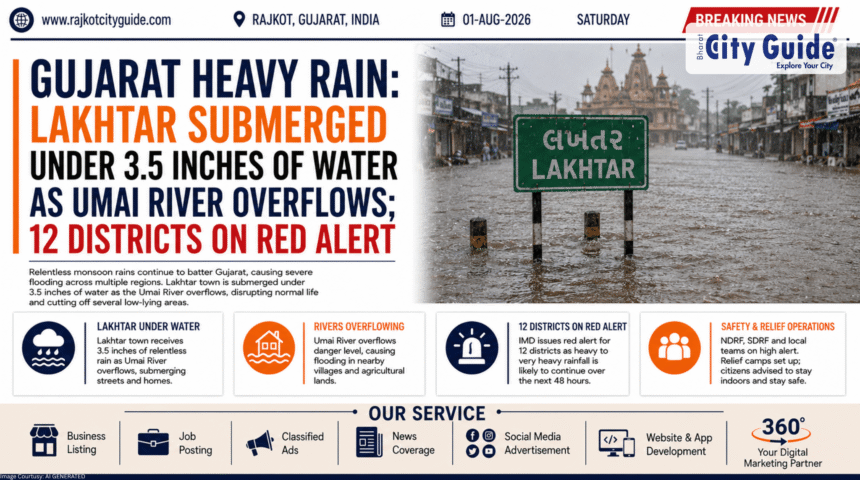
Nature has once again displayed its overwhelming power across Western India as severe weather conditions throw normal life into complete disarray. The state of Gujarat is currently experiencing an intense monsoon onslaught, resulting in major waterlogging, overflowing water bodies, and isolated rural communities. In a sudden atmospheric surge, Lakhtar taluka in Surendranagar district was battered by three and a half inches of rainfall in just two hours. This extreme cloudburst-like event caused the local Umai river to swell rapidly past danger levels, cutting off more than four neighboring villages from the regional grid.
The impacts of this current wave of Gujarat Heavy Rain extend far beyond the borders of Surendranagar. Recognizing the high risk posed by active meteorological systems moving over the state, the India Meteorological Department (IMD) has issued critical red alerts across 12 major districts. High-velocity winds combined with relentless downpours have forced regional administrations to close educational institutions, suspend non-essential transport, and deploy emergency rescue units to vulnerable zones.
For residents, travelers, and civic workers throughout the state, this massive weather event presents immediate safety risks. Understanding the sheer scale of this downpour, the areas most vulnerable to flooding, and the proactive measures taken by the government is essential for staying safe. This deep-dive report breaks down the immediate operational realities of the storm, the local geographical impact, and the systemic challenges faced by communities dealing with this historic monsoon season.
What is Gujarat Heavy Rain?
The phenomenon of Gujarat Heavy Rain during the peak monsoon months is driven by a complex interplay of low-pressure atmospheric systems arising from the Arabian Sea and the Bay of Bengal. When these massive moisture-laden winds hit the state’s varied landscape, they frequently stall, resulting in highly concentrated downpours over brief periods.
In the 2026 monsoon cycle, this pattern has become exceptionally pronounced due to multiple synchronized weather systems active over the region. Instead of steady, manageable precipitation spread across days, the state is experiencing sudden bursts of torrential rain. These sudden downpours dump inches of water onto urban and rural landscapes within hours, overwhelming natural soil absorption capabilities and challenging engineered drainage networks alike. This results in flash floods, rapid river swelling, and immediate threats to local human habitats.
Why This News is Important
The scale of the current weather crisis marks it as a highly significant event for public safety and administrative responsiveness. When a single locality like Lakhtar receives three and a half inches of water in a brief two-hour window, it exposes the extreme volatility of modern weather systems. The sudden overflow of the Umai river, which immediately isolated four distinct rural villages, emphasizes how quickly standard rural infrastructure can be cut off during a crisis.
Furthermore, the declaration of red alerts across 12 districts highlights the widespread nature of this storm. It indicates that the emergency is not confined to a single pocket or river basin but is a statewide challenge. The decision by district collectors to order the total closure of schools and colleges underscores the preemptive strategy adopted by the government to keep citizens out of treacherous floodwaters and minimize road traffic during rescue efforts.
Background Information
To fully comprehend the impact of the current floods, one must review the unique hydrological geography of Surendranagar and the wider Saurashtra plain. The region features numerous seasonal rivers and streams that remain mostly dry or shallow during the winter and summer months. These rivers, including the Umai river, serve as crucial drainage channels for the vast agricultural lands characteristic of rural Gujarat.
However, because these riverbeds are accustomed to lower baseline volumes, a sudden cloudburst event forces an immense volume of water through narrow channels simultaneously. Over the past few years, shifting global climate inputs have caused a noticeable increase in the intensity of short-duration rainfall events across Western India. Areas that historically received steady seasonal rains are now facing shorter, far more violent deluges. The current 2026 flooding in Lakhtar is a clear reflection of this shifting baseline, showing why modern emergency planning must prioritize rapid, localized responses.
Key Highlights
- Extreme Precipitation: Lakhtar taluka recorded a severe three and a half inches of rainfall within a narrow window of just two hours.
- River Overflow: The Umai river swelled past its banks, triggering immediate flash floods in adjoining low-lying areas.
- Communities Isolated: More than four rural villages have been rendered entirely inaccessible due to submerged connecting roads and bridges.
- Widespread Warnings: A total of 12 districts are placed under an active red alert warning for severe winds and heavy downpours.
- Educational Shutdown: District administrations have ordered the total closure of all schools and colleges to protect students.
- Disaster Deployment: Teams from the National Disaster Response Force (NDRF) and local fire departments are mobilized for active rescue missions.
Detailed Explanation of the Event
The recent escalation of the monsoon began as a dense, high-velocity cloud formation swept over the Surendranagar district. When the system broke over Lakhtar, the sheer volume of water overwhelmed local fields within minutes, turning village thoroughfares into fast-moving streams. The local automated weather gauges clocked the rainfall at a staggering three and a half inches, an amount that would normally take weeks to accumulate during a standard season.
As the water drained off the agricultural hardpan, it poured directly into the Umai river. The river basin could not accommodate the sudden influx, causing the water to burst over embankments and flood low-lying rural causeways. This rapidly blocked key transit bridges, leaving four key villages isolated from the main block headquarters. Residents in these areas found themselves surrounded by water, unable to travel for work, medical supplies, or provisions.
In response to this rural crisis and matching severe forecasts along the coastal and central belts, the state administration coordinated a sweeping defensive response. The IMD’s red alert designation triggered immediate emergency protocols in 12 distinct districts. District collectors used emergency broadcast systems to announce the immediate closure of all educational institutions, ensuring children remained safely inside their homes. Simultaneously, emergency control rooms began operating on a 24-hour cycle, directing rescue boats and field teams to extract stranded families from flooded agricultural settlements.
Impacts on the Local Population
The demographic disruption caused by this wave of extreme weather leaves a marked footprint across multiple sectors of society:
For Rural Communities and Farmers
The isolation of the four villages in Lakhtar presents immediate logistical challenges. Beyond the temporary lack of physical access, farmers are facing the grim prospect of waterlogged fields, which can rot young crops and wash away valuable topsoil. Livestock safety also becomes a pressing issue as low-lying barns face inundation.
For Students and Educators
The suspension of classes across schools and colleges protects students from the dangers of traveling through deep water or getting stranded away from home. While it temporarily halts academic schedules, it allows families to focus fully on domestic safety during the worst hours of the storm.
For Commuters and Travelers
State highways and rural roads across the 12 red-alert districts are experiencing severe delays, debris accumulation, and localized closures. Travel advisories have urged individuals to cancel all non-essential road journeys, keeping transit lanes completely clear for emergency operations and disaster relief vehicles.
Technical and Administrative Responses
The management of a widespread weather emergency relies heavily on coordinated operational strategies between multiple government tiers:
1. NDRF and Fire Department Mobilization
Specialized rescue teams equipped with inflatable boats, life jackets, and cutting tools have been deployed directly to the edges of the Umai river zone. Their presence ensures that any medical emergency within the isolated villages can be met with immediate waterborne evacuation support.
2. Controlled Water Releases from Reservoirs
With heavy inflows affecting dams and reservoirs across the 12 high-alert districts, irrigation engineers are working continuously to monitor water levels. Controlled releases are carefully calibrated to prevent sudden surges downstream, protecting riverside towns from artificial flash flooding.
3. Clear Public Communication Channels
State emergency portals are using localized SMS blasts and social media updates to keep the public updated on road closures, rainfall metrics, and shelter locations. This prevents the spread of misinformation and ensures citizens have access to verified safety facts.
Challenges and Mitigation Strategies
Managing an active flood crisis presents complex operational difficulties that require adaptive solutions on the ground:
Overcoming Rural Inaccessibility
The immediate challenge in Lakhtar is establishing supply lines to the four isolated villages. When causeways are deeply submerged, traditional vehicles cannot pass. To mitigate this, emergency services use specialized high-clearance tractors and rescue boats to deliver clean drinking water, dry food packets, and medical supplies directly to stranded communities.
Ensuring Electrical Safety
Heavy winds and downpours frequently down overhead power lines, creating severe electrocution hazards in flooded areas. Local electricity boards must implement strategic power cuts in heavily inundated zones, balancing the discomfort of blackouts against the absolute necessity of preventing accidental deaths.
Managing Urban-Rural Disparity in Relief
While large urban centers often have concentrated drainage infrastructure and rapid access to municipal aid, rural talukas like Lakhtar feature spread-out populations that require decentralized relief strategies. Ensuring that remote hamlets receive the same level of tracking and support as major cities is a key focus for regional collectors.
Future Outlook
As the active weather system moves across Western India, the state’s immediate focus will remain centered on preserving life and minimizing structural damage over the coming days. Once the current wave of Gujarat Heavy Rain subsides, a comprehensive rehabilitation phase will begin, focusing on repairing damaged rural roads, rebuilding eroded river embankments, and evaluating crop losses for financial aid packages.
In the long run, this event will likely accelerate efforts to upgrade rural infrastructure against extreme weather. Plans to elevate low-lying causeways, construct sturdier retaining walls along erratic seasonal rivers like the Umai, and expand automated weather monitoring networks will be vital to ensuring that rural communities are better insulated from sudden downpours in the future.
Frequently Asked Questions (FAQs)
How much rain fell in Lakhtar to trigger the current flood situation?
Lakhtar taluka was hit by an intense downpour that dumped three and a half inches of rain within a brief two-hour period, overwhelming local drainage capacity.
Which river overflowed, and how did it affect nearby villages?
The Umai river swelled rapidly past its safe capacity due to the heavy rain, flooding connecting roads and cutting off more than four neighboring villages from the main transit routes.
How many districts in Gujarat are currently placed under a red alert?
The India Meteorological Department has designated 12 districts under an active red alert due to the high probability of severe winds and relentless heavy rainfall.
Are educational institutions open during this weather emergency?
No, district authorities have ordered the total closure of all schools and colleges across the high-risk districts to ensure the safety of students and staff.
What emergency forces are active in the flood-affected zones?
Teams from the National Disaster Response Force (NDRF), local municipal fire departments, and police units are actively deployed on the ground to handle rescues and manage water hazards.
Is it safe to travel across Gujarat during the current red alert period?
Travel is strongly discouraged unless absolutely necessary. Multiple highways and rural causeways are experiencing severe waterlogging or debris blockage, making road transit highly hazardous.
Conclusion
The current crisis triggered by severe Gujarat Heavy Rain serves as a stark reminder of how quickly extreme weather can disrupt normal life and isolate vulnerable communities. The sudden deluge in Lakhtar and the subsequent flooding of the Umai river highlight the critical importance of robust early-warning systems and swift administrative action.
Through the timely closure of schools, the deployment of dedicated rescue teams, and clear public safety advisories across 12 high-alert districts, the government is working hard to protect lives and maintain order amid challenging natural conditions. For citizens throughout the affected areas, staying indoors, respecting local travel advisories, and relying on verified official updates are the most effective ways to navigate this intense monsoon season safely. By remaining alert and cooperative, the community can weather this storm and begin the vital process of recovery and structural reinforcement.